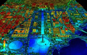
Geospatial Imaging
Geospatial imaging refers to the process of acquiring, analyzing, and interpreting data related to the Earth’s surface and its features
Automotive InCabin – Optics matter in the future.
One thing seems to be agreed on across the industry: InCabin vision applications will expand rapidly, similar to the evolution
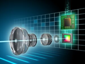
Lens Requirements for AI Vision
Developing a machine vision or embedded AI systems and scaling them for deployment are already challenging tasks. Converging these into

Embedded Vision Modules
If applied AI for embedded vision aims to replicate human understanding, then the optical stack plays a significant role in

Automotive Headlamp Optics
Lighting in automotive has come a long way. The earliest versions used candles, followed by fuel-based approaches burning carbide or

SWIR Imaging Optics
Short-Wave Infrared or SWIR is an imaging technology that traditionally has been used in biological, defense, and some industrial-related applications.

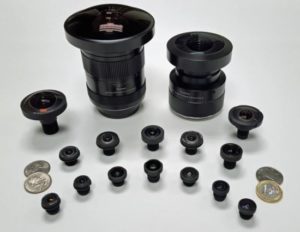
HOW ARE LENS ELEMENTS MADE ?
Digital imaging lenses are often made of multiple lens elements to achieve the required specifications. How are those lens elements

Basic Thread Considerations for Lens/Holder Pairing on Board-Mount Cameras
At Sunex, we get many questions about lens and mount (holder) threads when it comes to board-mount lenses. In this

An Optics Platform for Automotive Vision
New technologies, new application requirements, and new market segments are challenging every automotive vision program to consider and balance performance

Relative magnification and aspect ratio
It is well-known that the magnification of an imaging lens changes with the object distance (distance from the object to

Hydrophobic and Oleophobic Coatings
Applications in Imaging Optics Oleophobic refers to the physical property of a molecule that repels oil. Fluorocarbons are deposited to
Sunex Part Number Tutorial
Sunex has many online tools designed to help you find a lens according to your specifications that is best suited